---
title: "Data Schema: Groundwater Levels"
url: "https://help.esdat.net/en/article/data-table-definitions-groundwater-levels"
language: "en"
last_updated: "2026-10-09T15:28:38.165Z"
---
# Data Schema: Groundwater Levels
Data Schema
Groundwater depths (and/or elevations) are stored in the Groundwater and NAPL Levels table, Each Record requires a Location Code, Well, Date/Time and optionally a Monitoring Round.
Groundwater levels entered as Depths are converted in ESdat outputs as an Elevation, Depth below Top of Casing and Depth below Surface. In order to provide this conversion the Top of Casing must be populated in the Wells table, and the Elevation must be populated in the Locations table.
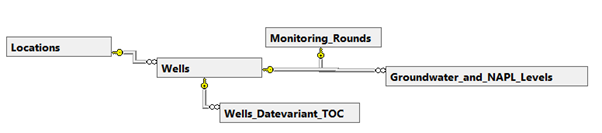
ESdat also supports changes in the Wells Top of Casing, as may be encountered due to subsidence or “benching” in mining operations. Groundwater depth to elevation calculations are able to take these TOC changes into account. Further information on the Wells Datavariant TOC table is available at [https://help.esdat.net/en/article/timevarient-toc](https://help.esdat.net/en/article/timevarient-toc)
## Groundwater and NAPL Levels
| PrimaryKey | Column | Type | Description |
| --- | --- | --- | --- |
| \* | SID | Integer | References Sites.ID - a unique integer for each Site. |
| | PID | Integer | References Projects.ID - a unique integer for each project. |
| \* | Location\_Code | Text(20) | References a Location in the Locations Table. |
| \* | Well | Text(10) | References a Well in the Wells table. |
| \* | Date\_Time | DateTime | |
| | Water\_Depth | Numeric | Depth to water below the Top of casing |
| | Water\_Elevation | Numeric | Elevation of Water Level if imported from historical data with no depth.
Note, the Water\_Depth value is converted to elevations in ESdat outputs by deducting the Water Depth from the Wells Top of Casing. |
| | Product\_Depth | Numeric | Depth to LNAPL or DNAPL |
| | Well\_Depth | Numeric | Depth to the base of the well. |
| | Dry | True/False | If the Well is dry. |
| | Units | Text(20) | m or ft, depending on the units being used for the Site. |
| \* | Measurement\_Method | Text(15) | Method used to measure the groundwater depth. Typically Dip or Logger |
| | Monitoring\_Round | Text(30) | Name of each monitoring round, makes extracting data that is obtained in one round over multiple dates easier. |
| | Well\_Depth\_Method | Text(255) | Method used to measure the well depth. |
| | Location\_Visit | Integer | References Location\_Visits.ID - a unique integer for each Location Visit. Relevant only for field samples collected in the ESdat Field Portal / App. |