
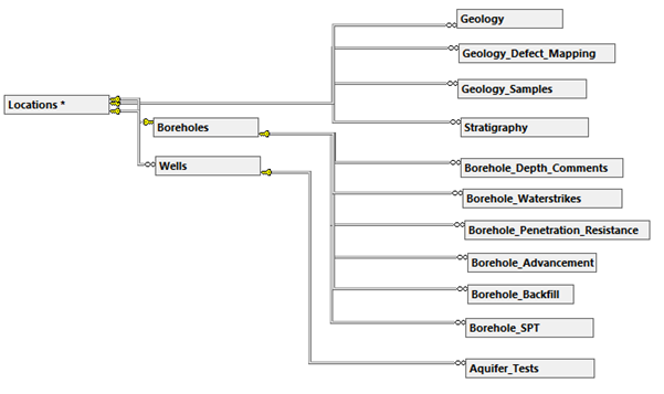
Data Schema: Boreholes and Geology
ESdat stores borehole and geology data that would be encountered in a groundwater or contaminated site investigation,as well as the more common Geotech data.
Tables and their relationships are shown below:
Boreholes
Information related to the borehole, is a 1 to 1 relationship with Locations. A Location may not be a borehole, but a borehole record must have a Location.
PrimaryKey | Column | Type | Description |
* | SID | Integer | References Sites.ID - a unique integer for each Site. |
| PID | Integer | References Projects.ID - a unique integer for each project. |
* | Location_Code | Text(20) | References a Location in the Locations Table. |
| Logged_By | Text(20) |
|
| Date_Commenced | DateTime |
|
| Date_Finalised | DateTime |
|
| Borehole_Diameter | Numeric |
|
| Diameter_Units | Text(8) |
|
| Total_Depth | Numeric |
|
| Refusal_Encountered | Numeric | Depth at which refusal is encountered |
| Drilling_Method | Text(60) |
|
| Drill_Company | Text(50) |
|
| Drill_Rig | Text(30) | The type of drill rig |
| Driller | Text(20) | The name of the head driller |
| Bearing | Text(20) |
|
| Plunge | Text(20) |
|
| Test_Pit_Length | Text(20) |
|
| Test_Pit_Width | Text(20) |
|
| Test_Pit_Construction | Text(100) |
|
| Comments | Text(1000) |
|
| Licence_Number | Text(30) |
|
| Depth_per_page | Numeric | For borehole outputs in ESlog |
| Completion_Description | Text(1000) |
|
| Checked_By | Text(30) | Who has reviewed the bore data / bore log |
| Checked_Date | DateTime |
|
Geology
Geology and Lithology data. Data can be stored either in individual components (ie Colour, Grain Size), or a full description can be included as a sentence in the Lithology Description Field.
PrimaryKey | Column | Type | Description |
* | SID | Integer | References Sites.ID - a unique integer for each Site. |
| PID | Integer | References Projects.ID - a unique integer for each project. |
* | Location_Code | Text(20) | References a Location in the Locations Table. |
* | Top_Depth | Numeric |
|
| Bottom_Depth | Numeric |
|
* | MultiLith_Num | Integer | Increments for each lithology being described over a single depth interval. |
| MultiLith_Descriptor | Text(255) | Allows for multiple lithologies to be logged as separate lithologies within the one depth interval. Descriptor would be "Interbedded With" or similar. |
| Lithological_Code | Text(100) | A code used to describe the lithology, from zRef_Lithology_Codes |
| Lithological_Description | Text(1000) | Free text description of the lithology |
| Primary_Major_Constituent | Text(50) | For example, for a Sandy Clay, the Primary Major Constituent would be Clay. |
| Secondary_Major_Constituent | Text(50) | For example, for a Sandy Clay, the Secondary Major Constituent would be Sandy. |
| Tertiary_Major_Constituent | Text(50) | For example, for a Silty Sandy Clay, the Tertiary Major Constituent would be Silty. |
| Minor_Components_Description | Text(255) | Descripton of the minor components. |
| Minor_Constituent_1 | Text(100) | Description of a specific minor constituent |
| Minor_Constituent_2 | Text(100) | Description of a specific minor constituent |
| Minor_Constituent_3 | Text(100) | Description of a specific minor constituent |
| Mineralogy | Text(50) | Describe the Mineralogy. |
| Formation | Text(50) |
|
| Stratigraphy1 | Text(50) | A stratigraphy interpretation tied to lithology layers. A separate Stratigraphy table is also available if more suitable. |
| Stratigraphy2 | Text(50) | A second stratigraphy interpretation tied to lithology layers. A separate Stratigraphy table is also available if more suitable. |
| Recovery_Method | Text(30) | Method by which the geological samples are being recovered. |
| Moisture | Text(50) |
|
| Colour | Text(100) |
|
| Munsell_Colour | Text(100) |
|
| Grain_Size | Text(30) |
|
| Recovery_% | Integer |
|
| Structure | Text(80) |
|
| Fracture_Spacing | Text(40) |
|
| Fracture_Spacing2 | Text(40) |
|
| Staining | Text(50) |
|
| Odour | Text(30) |
|
| HCL_Reaction | Text(50) |
|
| Major_Unit_Percent | Numeric | The percentage of the lithology that is the dominant lithology. |
| Upper_Boundary_Transition | Text(40) | Description of the upper boundary of the depth interval, it may be a sharp or gradual boundary with the overlying layer. |
| Soil_Consistency | Text(50) |
|
| Soil_Gradation | Text(70) |
|
| Soil_Angularity | Text(70) | For example, rounded, angular, sub-angular |
| Soil_Hardness | Text(20) |
|
| Soil_Shape | Text(70) |
|
| Soil_Deposition_Environment | Text(50) |
|
| Soil_Cementation | Text(20) |
|
| Soil_Plasticity | Text(50) |
|
| Soil_Dilatancy | Text(25) |
|
| Soil_Toughness | Text(20) |
|
| Soil_Dry_Strength | Text(30) |
|
| Soil_Percent_Fines | Numeric |
|
| Soil_Percent_Sand | Numeric |
|
| Soil_Percent_Gravel | Numeric |
|
| Soil_Fines_Description | Text(150) | Description of the fines component of a soil, where relevant |
| Soil_Sand_Description | Text(150) |
|
| Soil_Gravel_Description | Text(150) | Description of the gravel component of a soil, where relevant |
| Soil_Cobbles_Description | Text(150) | Description of the cobbles component of a soil, where relevant |
| Soil_Boulders_Description | Text(150) | Description of the boulders component of a soil, where relevant |
| Soil_USCS | Text(10) |
|
| Max_Grain_Size | Text(10) |
|
| Rock_Compressive_Strength | Text(30) | A first Compressive Strength Value |
| Rock_Compressive_Strength2 | Text(30) | A second Compressive Strength Value, if needed. |
| Rock_Weathering | Text(30) | Description of the weathering state of rock. |
| Rock_Bedding_Angle | Text(30) |
|
| Comments | Text(255) |
|
Geology Defect Mapping
Geotech defect data. Many of the field names below are technical, and for definitions of terms, such as "Waviness", "Aperture", "Joint Roughness Coefficient" the appropiate soils reference text should be referred to.
PrimaryKey | Column | Type | Description |
* | SID | Integer | References Sites.ID - a unique integer for each Site. |
| PID | Integer | References Projects.ID - a unique integer for each project. |
* | Location_Code | Text(20) | References a Location in the Locations Table. |
* | Top_Depth | Numeric |
|
* | Bottom_Depth | Numeric |
|
* | Fracture_Set | Text(20) |
|
* | Defect_Number | Text(10) |
|
| Type | Text(20) |
|
| Dip_Degrees | Text(10) |
|
| Orientation_Degrees | Text(10) |
|
| Roughness | Text(30) |
|
| Planarity | Text(30) |
|
| Waviness_Wavelength | Text(20) |
|
| Waviness_Amplitude | Text(20) |
|
| Joint_Roughness_Coefficent | Text(10) |
|
| Surface_Appearance | Text(20) |
|
| Aperture_Width_Prefix | Text(3) | <, > |
| Aperture_Width | Text(20) |
|
| Width_Units | Text(20) |
|
| Aperture_Observations | Text(255) |
|
| Infilling | Text(20) | Describe the infilling in the defects. |
| Termination | Text(20) |
|
| Persistence | Text(20) |
|
| Wall_Strength | Text(20) |
|
| Wall_Weathering | Text(20) |
|
| Seepage_Rate | Text(20) |
|
| Water_Flow_Rating | Text(20) |
|
| Water_Flow_Units | Text(20) |
|
| Comments | Text(255) |
|
Geology Samples
Core Sample Recovered
PrimaryKey | Column | Type | Description |
| SID | Integer | References Sites.ID - a unique integer for each Site. |
| PID | Integer | References Projects.ID - a unique integer for each project. |
| Location_Code | Text(20) | References a Location in the Locations Table. |
| Top_Depth | Numeric |
|
| Bottom_Depth | Numeric |
|
| Sampling_Method | Text(30) |
|
Date_Time | DateTime | ||
| Total_Recovery_Length | Numeric |
|
| Solid_Core_Recovery_Length | Numeric |
|
| RQD_Length | Numeric | Rock Quality Designation, used in Geotech. |
| Comments | Text(255) |
|
| Length_Units | Text(7) |
|
| Core_Number | Text(7) |
|
| Diameter | Text(7) |
|
Stratigraphy
Interpreted Stratigraphy information
PrimaryKey | Column | Type | Description |
* | SID | Integer | References Sites.ID - a unique integer for each Site. |
| PID | Integer | References Projects.ID - a unique integer for each project. |
* | Location_Code | Text(20) | References a Location in the Locations Table. |
| Top_Depth | Numeric |
|
| Bottom_Depth | Numeric |
|
* | Stratigraphic_Unit | Text(60) |
|
| Comments | Text(255) |
|
Aquifer Tests
Stores the results of Aquifer Test Interpretations. ESdat does not store the input data for rising head, falling head or pumping tests interpretations.
PrimaryKey | Column | Type | Description |
* | SID | Integer | References Sites.ID - a unique integer for each Site. |
| PID | Integer | References Projects.ID - a unique integer for each project. |
* | Location_Code | Text(20) | References a Location in the Locations Table. |
* | Well | Text(10) | Alternatively known as a Pipe, Piezometer; has a screened interval typically in an aquifer. Multiple Wells can be present for one Location. |
* | Depth_From | Numeric |
|
| Depth_To | Numeric |
|
* | Test_Type | Text(15) | For example Rising Head, Falling Head, Pump Test. |
* | Test_Date | DateTime |
|
* | Result_Type | Text(20) | For example, estimate, initial, final. |
| Conducted_By | Text(100) | Who conducted the test. |
| Result | Numeric |
|
| Result_Units | Text(15) |
|
| Interpretation_Method | Text(50) | Method used to obtain the iterpretation. |
| Interpreted_By | Text(100) |
|
| Comments | Text(255) |
|
Borehole Advancement
Stores the advancement information when drilling a borehole.
PrimaryKey | Column | Type | Description |
* | SID | Integer | References Sites.ID - a unique integer for each Site. |
| PID | Integer | References Projects.ID - a unique integer for each project. |
* | Location_Code | Text(20) | References a Location in the Locations Table. |
* | Depth_From | Numeric |
|
| Depth_To | Numeric |
|
| Drilling_Method | Text(60) |
|
| Diameter | Numeric |
|
| Diameter_Units | Text(10) |
|
| Start_Date | DateTime |
|
| End_Date | DateTime |
|
| Logged_By | Text(255) |
|
| Comments | Text(255) |
|
Borehole Backfill
Backfill in the borehole, such as grout, filter pack.
PrimaryKey | Column | Type | Description |
* | SID | Integer | References Sites.ID - a unique integer for each Site. |
| PID | Integer | References Projects.ID - a unique integer for each project. |
* | Location_Code | Text(20) | References a Location in the Locations Table. |
* | Depth_From | Numeric |
|
| Depth_To | Numeric |
|
| Backfill_Code | Text(15) | A code to describe the backfill, from zRef_Backfill_Codes |
| Backfill_Description | Text(255) | Free text description of the backfill |
Borehole Depth Comments
Comments related to a particular depth in the borehole
PrimaryKey | Column | Type | Description |
* | SID | Integer | References Sites.ID - a unique integer for each Site. |
| PID | Integer | References Projects.ID - a unique integer for each project. |
* | Location_Code | Text(20) | References a Location in the Locations Table. |
* | Type | Text(20) |
|
* | Depth_From | Numeric |
|
| Depth_To | Numeric |
|
| Comment | Text(510) |
|
| Date_Time | DateTime |
|
Borehole Penetration Resistance
Resistance in drilling
PrimaryKey | Column | Type | Description |
* | SID | Integer | References Sites.ID - a unique integer for each Site. |
| PID | Integer | References Projects.ID - a unique integer for each project. |
* | Location_Code | Text(20) | References a Location in the Locations Table. |
* | Depth_From | Numeric |
|
| Depth_To | Numeric |
|
| Resistance | Text(30) |
|
| Comment | Text(255) |
|
| Upper_Boundary_Transition | Text(40) |
|
Borehole SPT
Standard Penetration Test Data
PrimaryKey | Column | Type | Description |
* | SID | Integer | References Sites.ID - a unique integer for each Site. |
| PID | Integer | References Projects.ID - a unique integer for each project. |
* | Location_Code | Text(20) | References a Location in the Locations Table. |
* | Depth | Numeric |
|
| Method | Text(20) |
|
| Penetration_Units | Text(4) |
|
| Seating_Blows | Integer |
|
| Seating_Penetration | Integer |
|
| Blows1 | Integer |
|
| Penetration1 | Numeric |
|
| Blows2 | Integer |
|
| Penetration2 | Numeric |
|
| Blows3 | Integer |
|
| Penetration3 | Numeric |
|
| Blows4 | Integer |
|
| Penetration4 | Numeric |
|
| Sampler_Correction | Numeric |
|
| SPT_N | Text(30) |
|
| Comments | Text(255) |
|
Borehole Waterstrikes
Waterstrike and recovery when drilling
PrimaryKey | Column | Type | Description |
* | SID | Integer | References Sites.ID - a unique integer for each Site. |
| PID | Integer | References Projects.ID - a unique integer for each project. |
* | Location_Code | Text(20) | References a Location in the Locations Table. |
* | Depth | Numeric |
|
| Date_Time | DateTime |
|
| Minutes_Elapsed | Numeric |
|
| Recovered_Water_Depth | Numeric |
|
| Comments | Text(255) |
|