
Data Schema: Locations and Wells
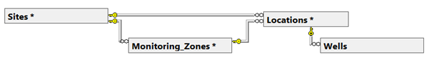
Most monitoring data in ESdat is associated with a Location, and potentially a Well. There may be one or multiple Wells (or piezometers, screened intervals) for each Location. A higher level discussion of the use of Locations and Wells in ESdat is covered in the specific article at https://help.esdat.net/en/article/locations
Locations can optionally be grouped into Monitoring Zones, and multiple Monitoring Zones may be present for each Site.
 Locations
PrimaryKey | Column | Type | Description |
* | SID | Integer | References Sites.ID - a unique integer for each Site. |
| PID | Integer | References Projects.ID - a unique integer for each project. |
* | Location_Code | Text (20) | A Code to identify a point (x,y) on the land surface. |
| x_coord | Numeric | The co-ordinate in the x-direction, a longitude can also be used. All values must be consistent within a single Site - the Co-ordinate System being used is defined at the Site Level. |
| y_coord | Numeric | The co-ordinate in the y-direction, a latitude can also be used. All values must be consistent within a single Site - the Co-ordinate System being used is defined at the Site Level. |
| Latitude | Numeric | A calculated field, based on the x_coord and y_coord and the site Co-ordinate System |
| Longitude | Numeric | A calculated field, based on the x_coord and y_coord and the site Co-ordinate System |
| Elevation | Numeric | Ground Surface Elevation |
| Description | Text(255) |
|
| Location_Type | Text(30) | The type of location, drop-downs are typically applied. |
| Monitoring_Zone | Text(100) | The name of a section of the site. |
| Survey_Method | Text(50) | For example, GPS, Approximation, GIS, Surveyor |
| Mapped_By | Text(50) | Who located the point (ie provided the co-ordinates). |
| Comments | Text(255) |
|
| Alternative_Name | Text(50) | Alternative name often used to refer to the location, or used historically. |
| Purpose | Text(255) |
|
| Asset_Code | Text(50) | For linking into a Asset Management System |
| Accepted | True/False | If the location is accepted/approved. Used to manage addition of new locations, which can be rejected and the data assigned to an existing location, or accepted |
| Accepted_By | Text(50) | Person who accepted |
| Accepted_Date | DateTime |
|
Wells
PrimaryKey | Column | Type | Description |
* | SID | Integer | References Sites.ID - a unique integer for each Site. |
| PID | Integer | References Projects.ID - a unique integer for each project. |
* | Location_Code | Text(20) | References a Location in the Locations Table. |
* | Well | Text(10) | A code to identify a Well, such as A,B,C etc.. Multiple Wells can be present for one Location. If only one well is present for a Location a dash (-) should be used for the Well value. |
| TOC | Numeric | The elevation of the Top of Casing |
| Stickup | Numeric | The height the Well sticks up above the ground surface |
| Top_Screen_Depth | Numeric | The depth to the top of the screened interval. |
| Bottom_Screen_Depth | Numeric | The depth to the bottom of the screened interval. |
| Monitoring_Unit | Text(50) | The aquifer unit that is monitored by the Well. |
| Base_Depth | Numeric | Bottom of the Well |
| Casing_Description | Text(30) | Description of the well casing, ie PVC, Metal etc.. |
| Inner_Diameter | Numeric |
|
| Screen_Description | Text(30) | Description of the screened interval and/or slots |
| Extraction_Usage | True/False | Indicator for when a well is used for water extraction (ie Pumping) |
| Metered | True/False |
|
| Comments | Text(255) |
|
| Water_Depth_Expected_Min | Numeric | For the purposes of alert Notifications when data is imported |
| Water_Depth_Expected_Max | Numeric | For the purposes of alert Notifications when data is imported |